Thachäl Dhäl Ridge Route, Kluane National Park
Disclosure: This post contains affiliate links. Please read our full disclaimer.
Updated February 14, 2018 with corrections: Jenessa Tlen, Interpreter Programmer for Kluane First Nation, emailed me to let me know that Tachäl Dhäl, as I was referring to it (along with a lot of other sites) is actually named Thachäl Dhäl.
We had this kickass plan for hiking Sheep Creek trail in Kluane National Park. During our first trip to the Thachäl Dhäl Visitor Center, the ranger mentioned that we could make a loop out of the trail instead of hiking it as an out and back. We were excited to finally hike a loop trail in Yukon.
Sheep Creek trail is a 6-mile roundtrip hike with 1,400 ft. of elevation gain. The trailhead is 1.6 miles from the Thachäl Dhäl Visitor Center. The trail brings you up to and along the ridgeline of Sheep Mountain, above Sheep Creek. After three miles on the ridge you would turn around to come back the way you went up.

Sheep Creek trail follows this ridgeline above Tachal Dhal Visitor Center.
The ranger said that there’s a route (remember from my King’s Throne post that a route is an unmaintained and unmarked trail) that connects to the end of Sheep Creek trail. It’s called Thachäl Dhäl Ridge route. This route follows the remaining ridgeline on Sheep Mountain and brings you back down the east ridge of the mountain to the Alaska Highway, about 6 miles from the visitor center.
Thachäl Dhäl does not means Sheep Mountain in First Nation, like I thought (and other sites constantly mention). Sheep Mountain is the English name, probably named after the abundant Dall sheep that live on the mountain. According to Jenessa Tlen, Interpreter Programmer for Kluane First Nation, Thachäl Dhäl means "skin scraper" or "stretcher mountain" because of the shape of the mountain.

The farthest-most right flank of the mountain is the way up Tachal Dhal Ridge route. Alaska Highway runs along the base of this mountain next to Kluane Lake.
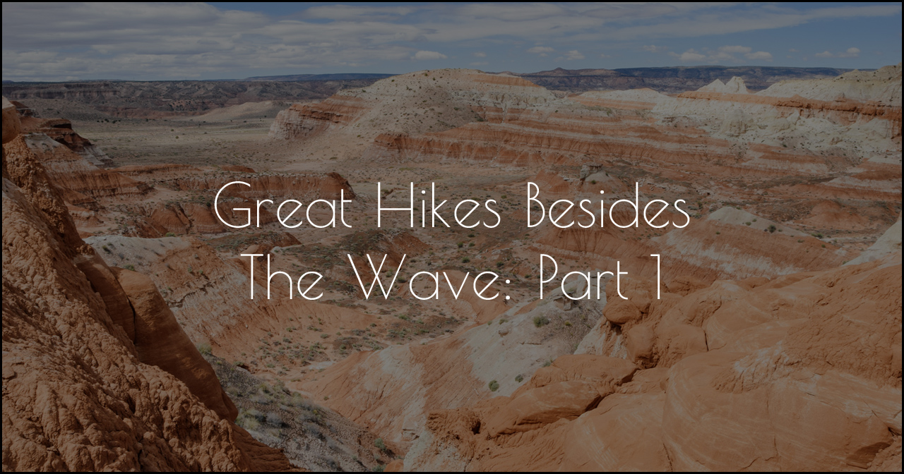
To connect the loop, hikers would either have to walk back to the trailhead via the highway, park a vehicle at each end, or use bicycles. Our plan was to drop our mountains bikes off at the Sheep Creek trailhead, drive to the Thachäl Dhäl Ridge trailhead, park the truck, hike from there, finish at the Sheep Creek trailhead, then ride our bikes on the highway back to the truck. The ranger said that coming down the Thachäl Dhäl Ridge route is difficult because it’s really steep and loose.
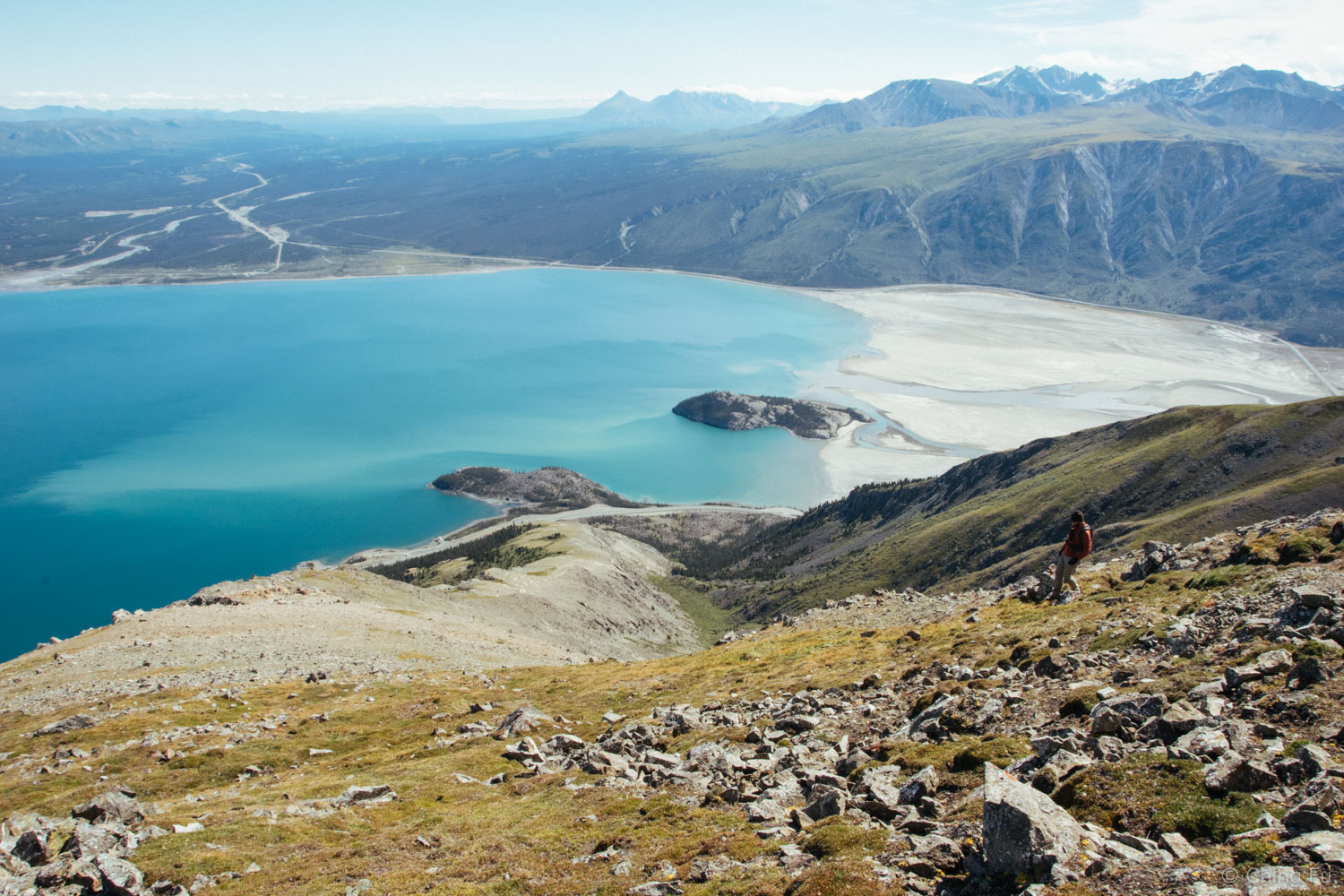
Can you find me?
We were so excited about this plan! We waited for the weather forecast to look good and drove back out that way. As we were locking up our bikes at the Sheep Creek trailhead, we noticed a sign on the bulletin board that said Sheep Creek trail and the surrounding areas would be closed due to bear activity. It wasn’t closed just two days ago when we were there, though the ranger had mentioned there was a bear in the area. But what really confused us was that the sign said this was effective on August 8 and it was August 7. Hoping for the best, we left our bikes locked up and drove to the visitor center to clarify. Honestly, I was just going to go ahead and complete the loop because the effective date wasn’t until the next day. But we decided that we should make sure – because being in the news about being eaten by bears would be kind of embarrassing. And we didn’t want to disturb the bears if that was the case.

Damn sign.
It turned out that the effective date was a typo and the closure was effective immediately. But we were told the Thachäl Dhäl Ridge route was still open from the trailhead up to where it meets Sheep Creek trail at the peak. But this meant we couldn’t complete our awesome plan.

We had views of Kluane Lake on our entire way up the mountain.
So up Thachäl Dhäl Ridge route we went. It blew. The route is 3.8 miles roundtrip with 2,900 ft. of elevation gain. Just the day before I came down with something that sucked all the energy out of me. I didn’t realize exactly how useless I was until I started hiking and thought I might actually not make it to the top. The beginning of the route had a worn in footpath, but about 1/3 way up the mountain the path disappeared. Luckily the ranger had told us to stay on the right side of the rockslide and we had scouted it out when we were last there. But the rest of the hike was finding your own route. It was steep and windy. I dreaded coming back down; I wasn’t sure if I would have enough energy to focus on the trail and my footing going downhill.


Once we made it to the top, we decided to continue hiking along the ridgeline until we got to the highest point, which is also where we believed Sheep Creek trail started. Luckily this section was easy.

At the top we dropped down before hiking back up to get to the highest point on the trail.
From the highest point on the ridge I could see Sheep Creek trail laid out before me and it was such a tease. The urge to say fuck it and continue down Sheep Creek trail back to our bikes was strong. But I didn’t.

Sheep Creek trail continues over these peaks. Slim River is the dried up riverbed in the photo.

Hiking to the highest point before turning around to go back down.
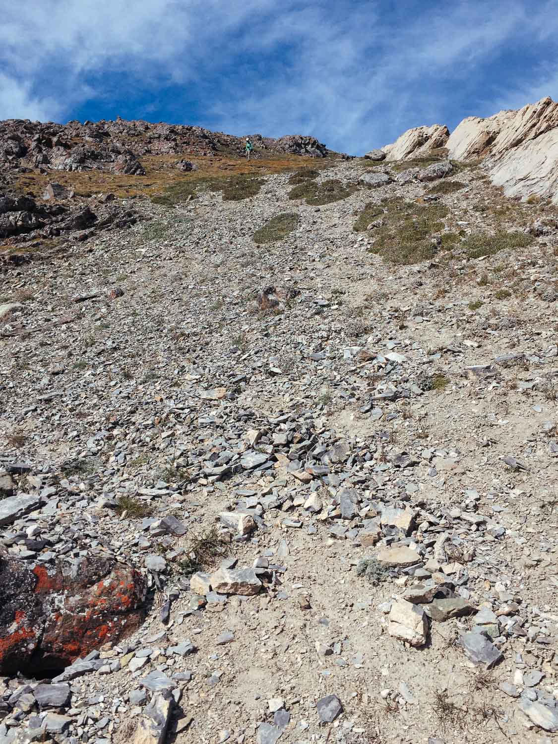
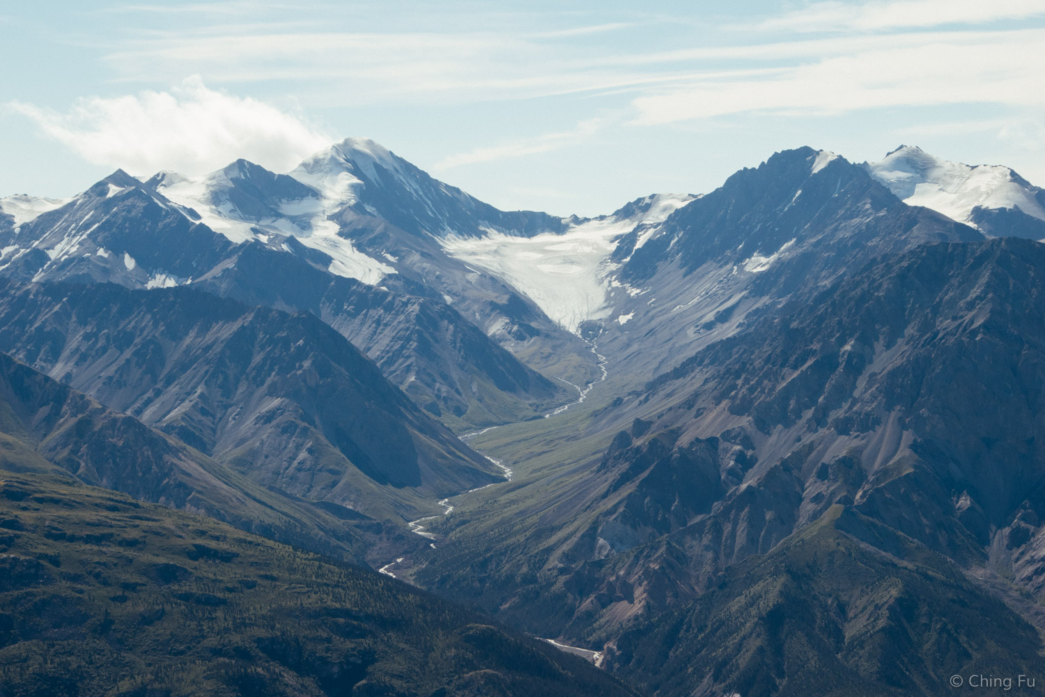
Standing on the ridgeline we could see Slims River, Kluane Lake, Kaskawulsh Glacier, Ruby Range, Mt. Wallace, Outpost Mountain, Red Castle Ridge, and Kluane Plateau. Although to be honest, because we didn’t actually have a detailed map we couldn’t tell exactly which mountains and ranges were what. But that didn’t totally matter. The views went on forever and it was unbelievably beautiful.

It’s also recommended to hike up Thachäl Dhäl Ridge route and down Sheep Creek trail rather than the other way around because it’s a lot easier to find a route looking up a mountain than down a mountain. There were a couple of sections on our way back down Thachäl Dhäl Ridge route where we had to stop, backtrack and find another way to go.
Even though we weren’t able to complete our hike as a loop, we were glad that we waited until a clear and sunny day to hike. An overcast day wouldn’t have done the scenery any justice and it would’ve been a bummer to miss out on that.

Although I wouldn’t recommend hiking Thachäl Dhäl Ridge (because of how hard coming down is on the knees), I’d recommend hiking Sheep Creek trail. In my opinion, making it to the top of Sheep Mountain is a must.

Enjoying the view of Kluane Lake.
TIPS
If you plan to hike Thachäl Dhäl Ridge, download Yukon Hiking’s tracks to help you stay on the best route.
I would avoid hiking on the ridgeline on a really windy day because of how exposed it is at the top (there isn’t any tree coverage).
You’re in bear country so bring bear spray.
There are herds of sheep on the mountain. Stay at least 165 ft. away from them (that’s the distance recommended by the park). Keep your dog leashed and away from the sheep.
We did this hike on August 5, 2016.