
Hikes Of Mt. Baker-Snoqualmie National Forest
Mt. Baker-Snoqualmie National Forest is large, like 130+miles-from-the-Canadian-border-of-the-Cascades-to-the-northern-boundary-of-Mt. Rainer kind of large. It has a total area of 1,724,299 acres.
The last time I was in Mt. Baker-Snoqualmie National Forest by Granite Falls, WA was over a year ago. I was in Seattle for a work event and got the chance to go hiking off Mountain Loop Hwy. The two hikes I did were so stellar that I knew I had to go back again one day.
We partially chose to stay off Mountain Loop Hwy in Mt. Baker-Snoqualmie National Forest because of that reason. But also because the Mountain Loop Hwy area has a ton of trails. We found a nice boondocking spot for the Toaster and called it home.
Below is a quick summary of the hikes we did along with tips to help you make the most of your hikes:
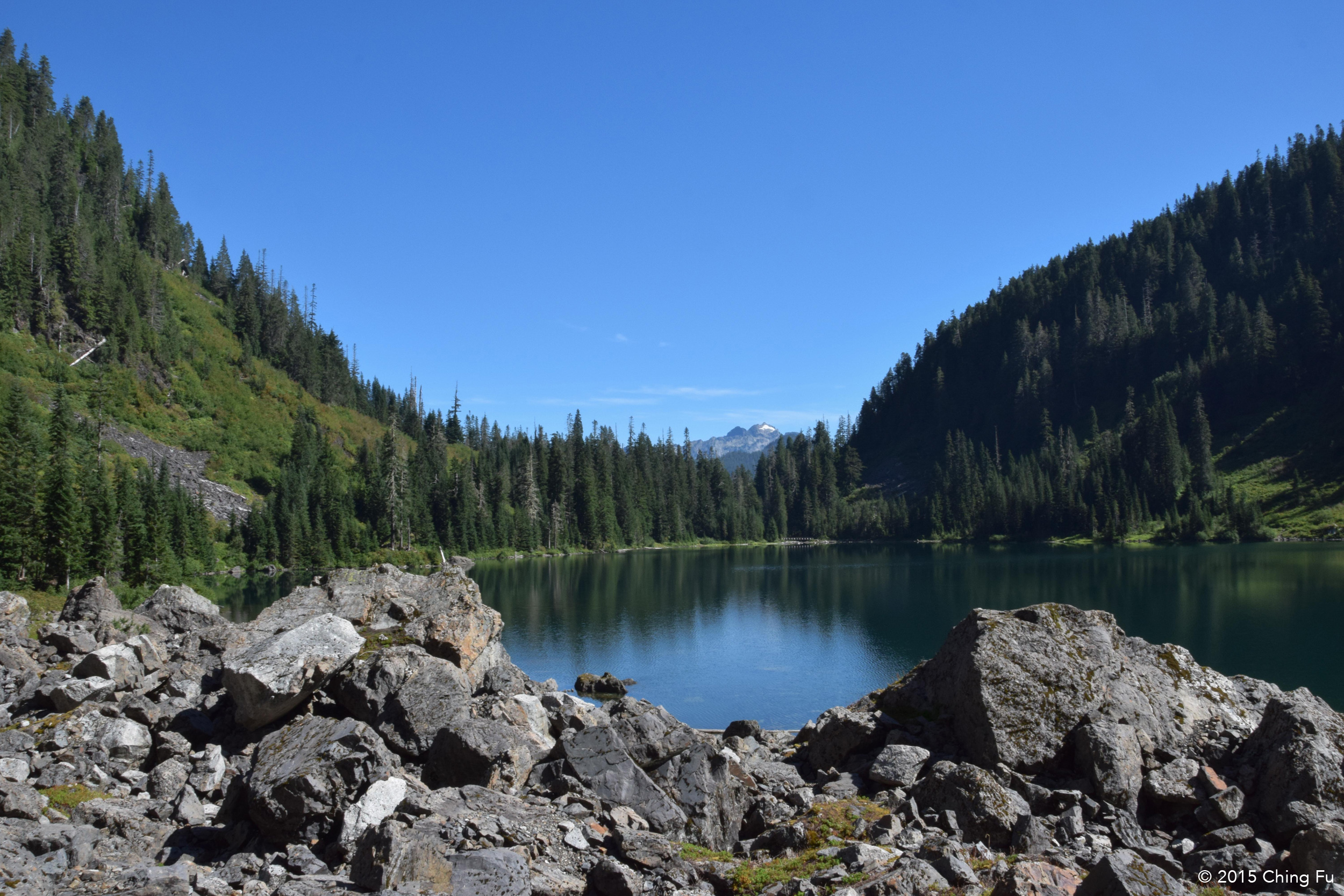
Lake Twentytwo
Lake Twentytwo is located at the northern base of Mt. Pilchuck, a classic northern Cascade mountain. It was early June the first time I hiked to Lake Twentytwo. Snowfields stretched out across the boulders next to the trail and at times spilled into the trail itself. The melting snow from above created an endless number of waterfalls cascading down Mt. Pilchuck as the lake’s backdrop. Talk about jaw-dropping scenery.
The lake looked a lot different this time around. For one all the snow was gone, which meant so were the waterfalls. But it was also sunny and clear so I actually got a good look this time. It was still worth the hike. It’s only 5.4 miles round-trip, but it has a few steep talus switchbacks.


Tips:
- It’s a very popular trail and the trailhead parking lot fills up very quickly on the weekends (to the point that there’s no parking available). If possible, avoid hiking there on the weekends. Even on the weekdays it gets busy. If you want the trails and lake to yourself for just a bit then we would recommend getting on the trail by at least 8 AM if not earlier during the weekday.
- Definitely hike the additional 1.2 mile trail that loops around the lake.
- The lake is swimmable if you want, so bring a towel (and maybe a swimsuit).
Kelcema Lake
Kelcema Lake is my favorite lake so far and I kind of don’t want to tell you about it. Except that it’s a fairly well known lake already so…This lake is located 4 miles up FS 4052, the fire road we were boondocked off of. It’s only a 0.5 mile hike in from the parking lot. We thought this would be perfect for Tybee, except that there are numerous rutted out, rooty, steep sections that she can no longer do – so we just carried her over those. Somehow we had the lake to ourselves when we were there (but from our RV we could see all the traffic going up the forest service road to the lake, especially on the weekend). The lake itself is stunning. A fairly large lake with a couple of good lakeside spots to hang out by. It’s a great swimming lake! Did I mention that I love this lake? We saw a really good spot to camp above the lake and had planned to come back to camp for a couple of nights, except our truck brakes failed and cancelled those plans.


Tips:
- Leave your trailer behind when driving up this road. It’s narrow and the only turn-around spot is at the parking lot, which isn’t a large one.
- Bring your stuff for swimming!
- There is a backcountry toilet by the lake.
Ashland Lakes
I’m sad to say that the lakes themselves aren’t much of a sight. Upper Ashland Lake looked mucky and can’t compete with lakes like Kelcema and Twentytwo (perhaps because it’s been a dry season and the lake level is lower than usual). Lower Ashland Lake was nicer looking but don’t plan to go swimming in either; you would have to wade past several feet of slime before getting to clear water. The scenery along the 5.5 miles round-trip hike isn’t too exciting, although the sphagnum bogs are pretty neat. What is worth checking out is the trail construction. Because the trail goes through sphagnum bogs, a lot of boardwalks were constructed so hikers could actually get to the lakes. The trail builders used a variety of materials for the boardwalks – from planks of wood to logs to circular log sections to a combination of all those in one section.
There are also a couple of tent platforms by Upper and Lower Ashland Lake, and numerous designated campsites and cooking sites by the lakes.


Tips:
- This was the only hike that we went on that required the Discover Pass.
- Since you can’t get the Discover Pass at the Verlot Public Service Center, be sure to get it online before you get out.
Mt. Pilchuck
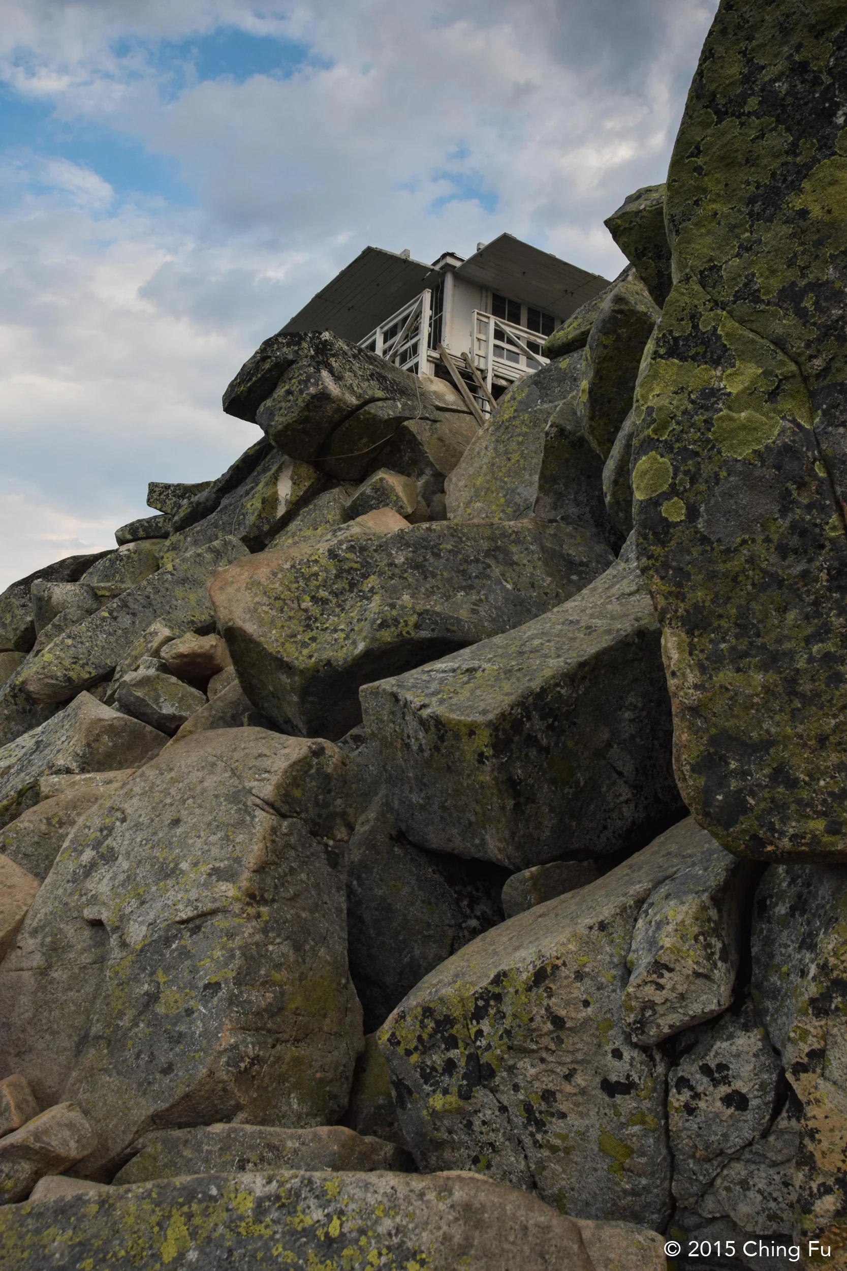
This is a MUST DO hike. The first time I hiked this trail was about a week after my initial Lake Twentytwo hike. The entire Mt. Pilchuck trail was covered in snow. It was an amazing hiking experience, especially for someone from out east who rarely gets to hike in snow, especially that much snow. But the clouds never did part at the summit that day. I’ve wanted to go back and actually see this spectacular 360-degree view of Mt. Rainer, Mt. Baker, Glacier Peak, and the Olympics that I kept hearing about.
We arrived at the trailhead at 3:30 AM for our “alpine start”-- Jerud and I wanted to see the sun rise from the fire lookout at the peak. And that was the best decision we could have made. Hiking at night is a cool experience that we just don’t do enough of. This is a difficult hike. Even though it’s a short trail (5.4 miles round-trip) it is steep (starts at 2,200 ft. and goes to 5,324 ft.) and rocky – very rocky. It was approaching dawn when we got closer to the peak, creating outlines of the mountain ridges and boulders in the distance. One thing I love about hiking in the dark is the surprise view when the sun illuminates everything you passed on the way up the trail. We arrived at the fire lookout with enough time to watch the sun come up from the horizon. The clouds parted enough so we had the view that I kept my fingers crossed for. We even got to catch a slight glimpse of Mt. Rainer.


Tips:
- Forest Road 42 that leads to the trailhead is riddled with potholes. Give yourself extra time to drive the 7 miles to the start.
- Like Lake Twentytwo, this is a very popular hike. Start as early as possible. Even with our alpine start we shared the fire lookout with two other hikers.
- Bring extra clothes because the peak gets chilly and windy.
- Because of its high elevation snow can last on this trail longer than other hikes, please check the trail condition before you head out. The snow makes this trail a lot more difficult to hike and to navigate.
- Scrambling over large boulders and climbing up a ladder is necessary to get to the fire lookout. Be prepared to have to carry your dog up to the lookout like we did with Tyki.
Coal Lake
The main reason why we went to check out Coal Lake was because it was only a 0.1 mile hike in and we hoped Tybee could spend the day swimming. But it was a chilly day, Coal Lake didn’t have any beach areas to hang out, and our truck brakes had just gone out before we got to the parking lot. We still hiked out to the lake and hung out for a bit before dealing with the reality of our situation. Coal Lake is about 600 ft. higher in elevation and smaller in size than Kalcema Lake. But it has similar northern Cascadian lake features to Kalcema Lake. Coal Lake was picturesque in a way that made us want to simply stand back and look at it rather than jump in.
The drive up Coal Lake Rd (FS 4060) was unlike any of the other drives. The driver side of the road had a wide range view of the valley, and a sharp drop off. We were very surprised when we realized that we could see a couple of ice caves halfway up Big Four Mountain across the way. The Big Four ice caves that you can hike to were closed for the summer due to a recent accident. But being able to see them was a really nice treat.


Tips:
- If the weather is warm enough bring your swim suit and walking shoes so that you can hike around the lake until you find a good spot to jump in.
General Tips:
- Washington Trail Association (WTA) has an incredible website with tons of detailed information on trails throughout Washington. Hikers also have the ability to post reviews of hikes and because the site is heavily used, majority of the reviews are very current which gives you recent conditions on road and trail conditions along with what’s blooming.
- Sometimes there’s nothing like holding a trail guidebook in your hands to flip through. In that case, we highly recommend Day Hiking North Cascades (Mount Baker/Mountain Loop Highway/San Juan Islands by Craig Romano.
- The majority of the trailhead parking lots in this area require the NW Forest Pass. The annual America the Beautiful national parks pass will also work in place of the NW Forest Pass.
- The Verlot Public Service Center also sells the NW Forest Pass. Since they have limited hours (Thursday – Sunday, 8 AM – 4 PM) there is a vending machine outside the office for the NW Forest Pass.
- Keep your eyes out, there are a couple of trails in this area that require the Discover Pass, which you can’t get at the Verlot Public Service Center but can get online.
- There’s not any kind of cell service (at least for Verizon) in this area. So do all your internet research before you leave Granite Falls (closest town).
