Jasper To Whitehorse On The Alaska Highway
We only gave ourselves 4 days to drive 1,167 miles from Jasper to Whitehorse because we got delayed leaving Missoula, MT by 4 days, had to be in Whitehorse by a certain date, and decided to spend the majority of our free time in Banff and Jasper National Park. This meant we didn’t really have the time to get out of the truck and explore, but when we did we weren’t disappointed.
Jasper to somewhere north of Grand Prairie, BC
About 100 or so miles after leaving Jasper, the mountains disappeared and the landscape turned into prairie land. Gas pipelines were frequently seen on the side of the road as we drove to Grand Prairie.

Mountains slowly turn into prairies.
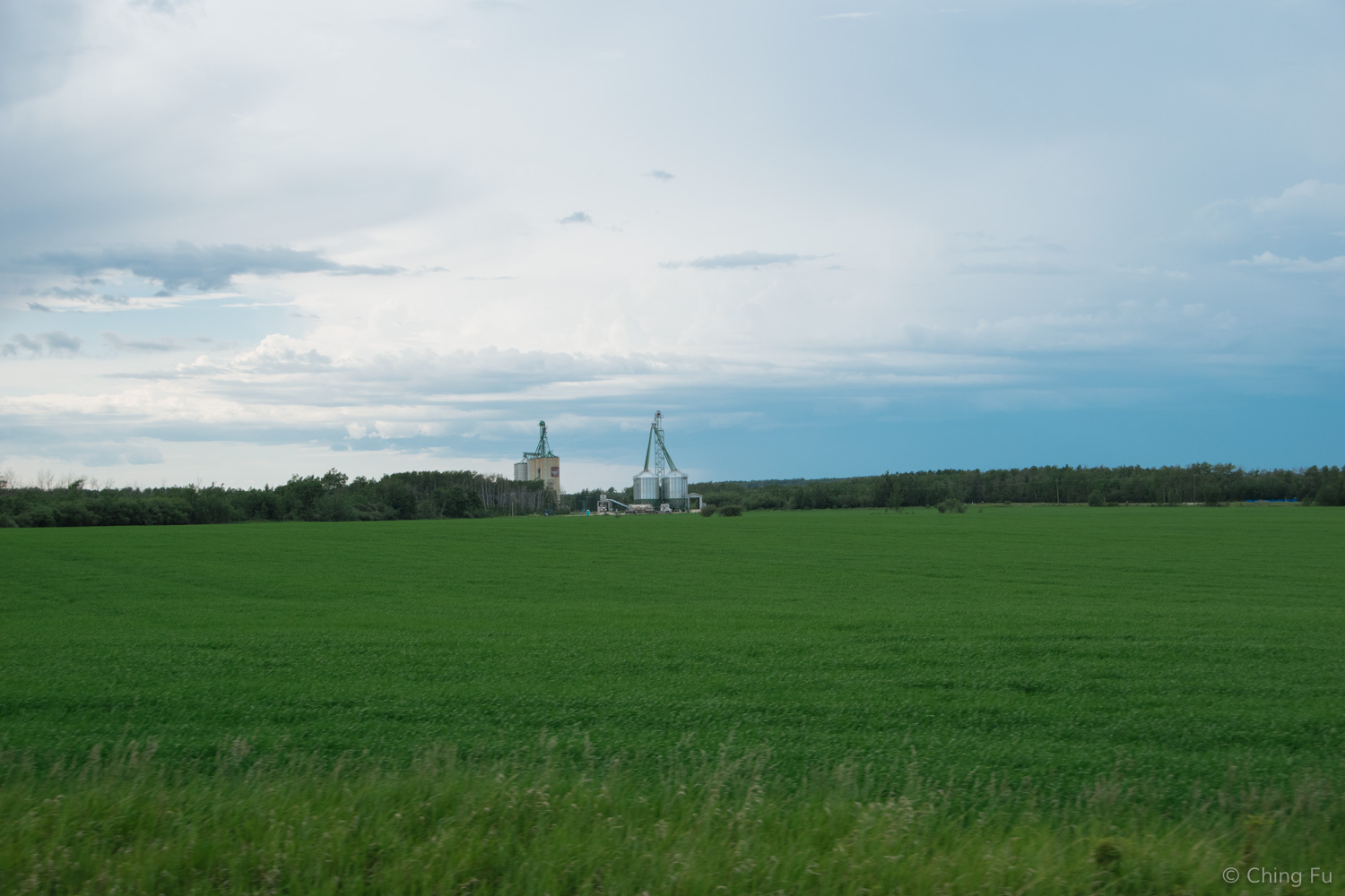
Fields outside the city of Grand Prairie.
When we stopped at the Grand Prairie visitor center to spend a couple of hours on their free WiFi, we found the RV kitchen had once again exploded (the last incident was a lot worse when we had arrived in Borrego Springs, CA). This time it was a mix of soy sauce, Chinese cooking wine and dry beans everywhere in the kitchen. It all somehow snuck out of one of our baby-locked kitchen cabinet door. Since there hadn’t been much of a selection in Jasper, we stocked up on groceries while we were in Grand Prairie.

This doesn't include all the broken eggs inside the fridge.
We had plans to boondock at a free provincial park that we found using Ultimate Campgrounds, but on our way there we came across this large empty field that was very enticing.
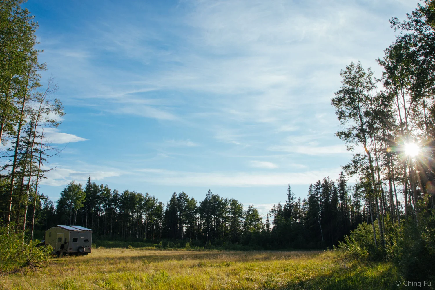
Home for the night.

Tyki was beyond thrilled to be out of the truck.
Most of the land seemed to be owned by a gas company because the company signs marked their land in between swaths of forest. But this field didn’t have any signs and we were so tired of driving in general - and especially on Hwy 52. So we decided to stay here for the night instead of driving further down the road, only to have to turn around and drive back out it in the morning.
There were moose tracks all around where we parked in the field. But we never saw an actual moose.
Jerud demonstrating how wide a moose step is.
Somewhere north of Grand Prairie in BC to Beaver Lake, BC
We arrived Dawson Creek the next morning. It turned out that if we had just stayed on Hwy 40 instead of turning off onto the smaller gravel Hwy 52, we would’ve found several pull outs that we could have crashed for the night instead of in the field. But the field was definitely nicer.
Mile 0 of the Alaska Highway is in Dawson Creek. The British Columbia government had originally suggested the idea of a highway connecting to Alaska back in 1929. But over the years, the U.S. and Canada went back and forth on whether or not they wanted to move forward with the construction of it. It wasn't until the Pearl Harbor attack in 1941, that changed both countries minds because the highway would be useful as part of a larger defense against the Japanese. The construction of the Alaska Highway started in March 8, 1942 and in less than 8 months the 1,700 mile long highway was completed. The Alaska Highway is now only 1,387 miles due to rerouting and reconstruction over the years. It took over 10,000 Army Corps of Engineers soldiers and over 250,000 tons of materials to complete the Alaska Highway.

I took a total of five photos all day, which tells you how uninteresting this section of the drive was for us. We knew that the Alaska Highway condition would be less than ideal. Thanks to permafrost, sections of the highway is always under construction during the summertime. We had heard stories of people’s windshield breaking from loose gravel getting tossed up, along with other parts of their RVs getting trashed. But I was surprised to find the condition to be not as terrible as I imagined based on what people said. More than anything it was how slow we had to drive that bothered me. Due to the construction that was happening on the highway, there was a lot of stop and goes. Although we soon learned that it was best to drive slow even when the road condition was fine because we came across a few surprise dips between the good and bad sections of highway that jolted the RV really badly.

Beaver Lake, BC to Watson Lake, Yukon
We hit the road early because there were several stops we wanted to make. The rain hadn’t let up overnight and everything was gloomy.

I think there are really pretty views of Muskwa River Valley along this section of the highway.

But we only got to see this.
There was one section of the Alaska Highway on this day that was absolute bullshit. It was actually the worst section to Whitehorse. The entire width of the highway had been torn apart for about almost 2 miles. It had potholes and loose rocks everywhere. For most of it I drove on the left side of the road because that seemed to have the least shitty conditions. When I wasn’t driving on the wrong side of the road, I was swerving left and right, and sometimes on the shoulder to avoid the potholes. Two miles doesn’t sound long, but when you’re creeping along at 10 mph pulling a trailer that you’re trying to prevent from shaking to pieces, it’s a long 2 miles. (Sorry, I didn't stop to take photos of this section.)
What soon made up for the crappy road condition were the best cinnamon buns we’ve ever had. Seriously. So make sure to stop at the Tetsa River Lodge that’s right off the Alaska Highway.
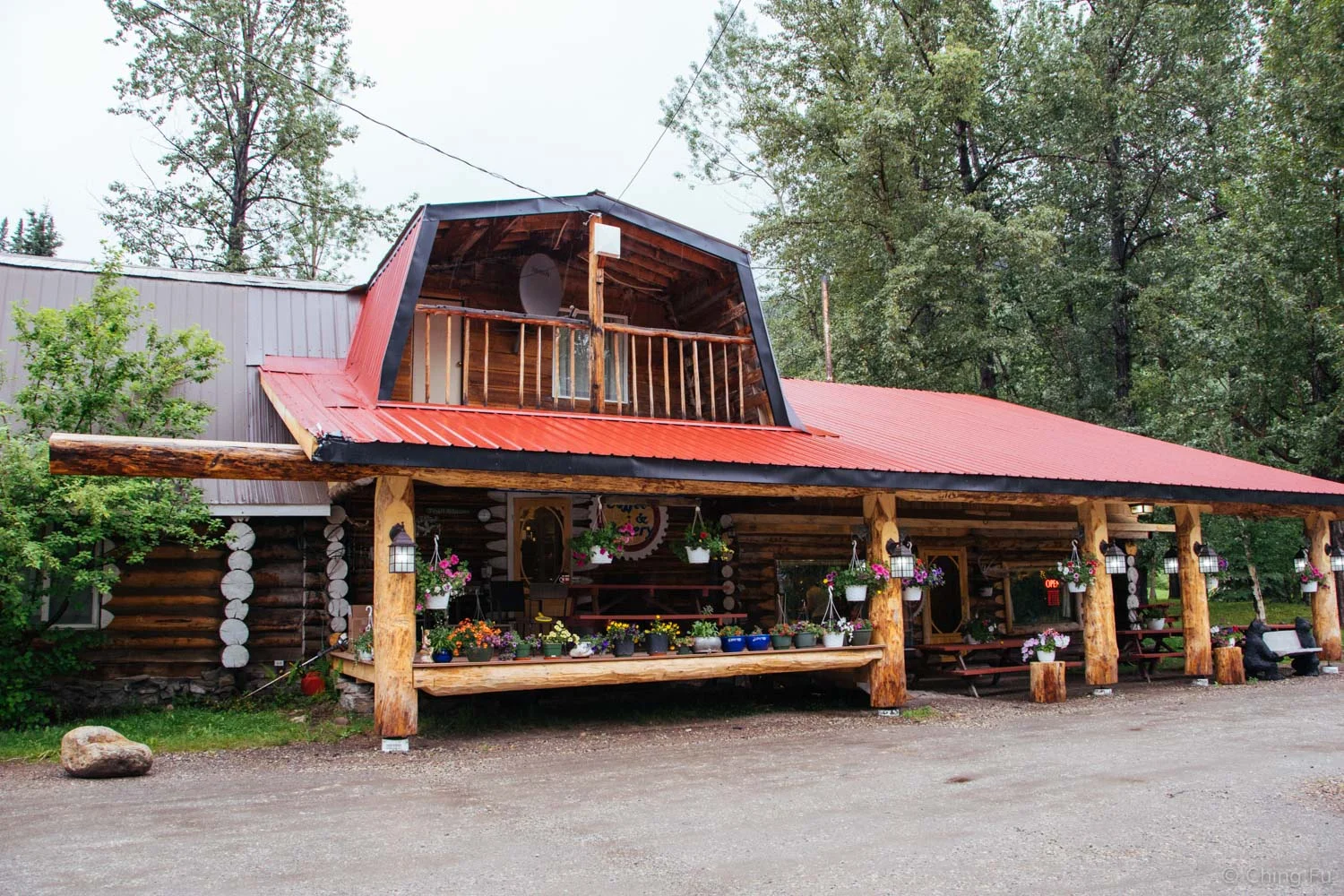
They are homemade, warm, sticky as heck, and a good price. For CAD $5, Jerud and I shared a bun. Although we easily could have each eaten our own. Instead, we bought another one to go. (The only downside to these buns is that they are all pre-wrapped on Styrofoam plates. Bring in your own fork so at least you don’t have to use a disposable plastic one.)

The highest point along the Alaska Highway is Summit Lake at 4,250 ft. We wish the sky had been clearer and we had more time because we would have liked to check out Stone Mountain Provincial Park. It looked like it would have been really pretty.

Summit Lake


Rushing River
But we did get lucky and the sun came out when we arrived at Muncho Lake Provincial Park. We took advantage of the good weather and ate lunch by the lake. Spending the night here was extremely tempting. The campsites sit along the lake with greats views and easy access to the water.


Our next stop was the popular Liard River Hot Springs Provincial Park that most travelers stop at on their way to Alaska. For CAD $5 per person (or free if you get there earlier in the season), we got to relax in the springs. While the hot spring used to be a lot more natural, it still feels more like hiking out to a cabin than going to a hotel resort. Thankfully the hot spring hasn’t been converted into a large concrete swimming pool where the spring water is piped in. Hanging out in the water still feels like you’re in the middle of the woods surrounded by trees and ferns. But there are also really nicely designed bathrooms and changing rooms.

Less than 0.5 mile walk in from the parking lot.
It's so worth the stop.

There are tons of bison along the Alaska Highway just outside Liard Hot Springs.
Thanks to Freecampsites we found a great boondocking site on the shore of Watson Lake, behind the Watson Lake airport.


Watson Lake to Marsh Lake, Yukon
I woke up thinking I had overslept and missed my 3 AM turn to pee Tybee. It was bright outside, so bright that I thought it was 6 AM. Freaked out I quickly glanced down at my watch only to see that it was 3:30 AM. Instead of being worried that she peed the bed, I was ecstatic that we were finally north enough to experience the “midnight sun”! It was such a wonderful experience, one that I would keep on getting for the next several weeks.

Yes, this is what it looked like at 3:30 AM!
The town of Watson Lake is also home to the Sign Post Forest that was started by Carl K. Lindley in 1942 when he was working on the construction of the Alaska Highway. Since then, travelers from all over the world add signs of their hometowns to the forest. There are now over 75,000 signs.
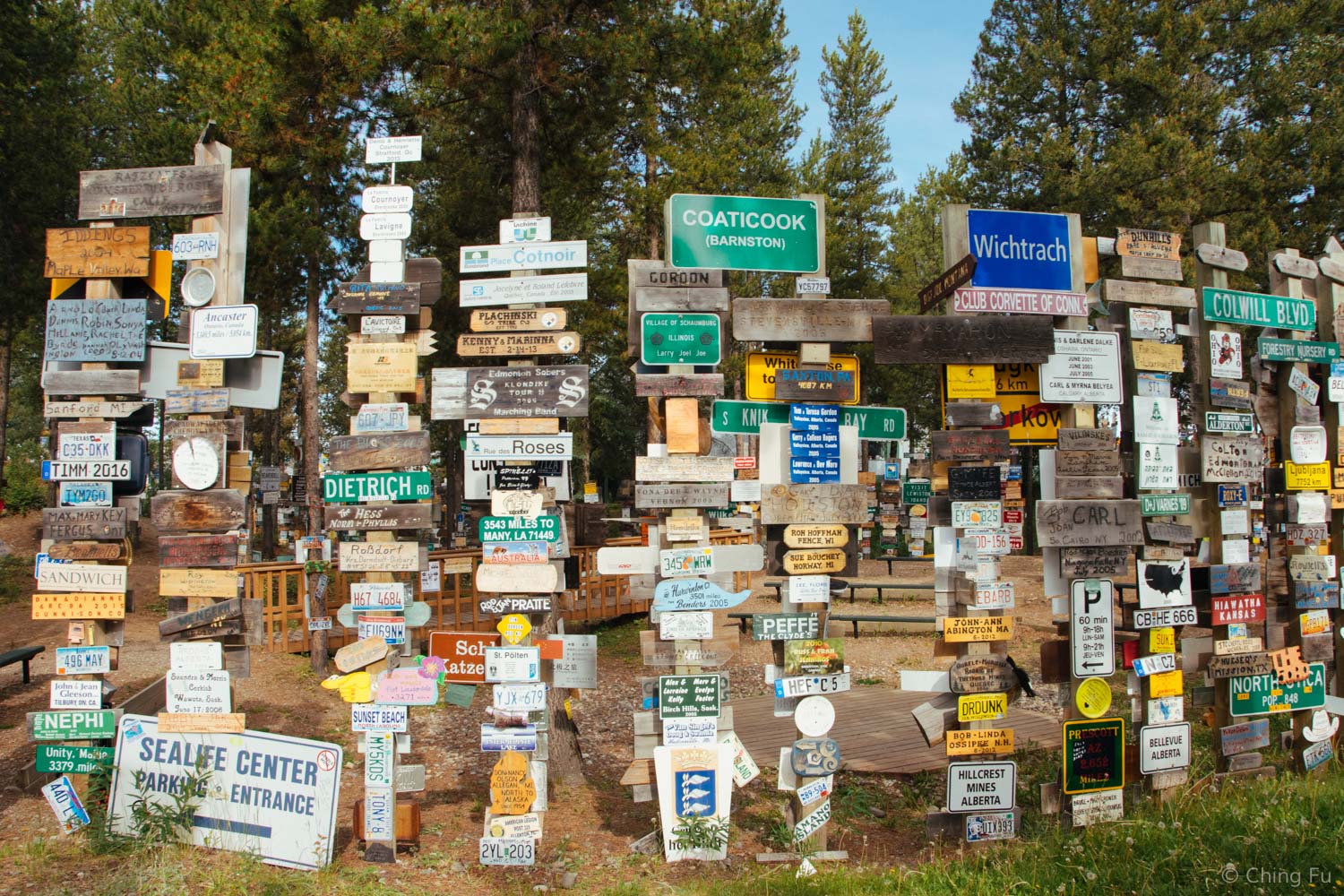
We spent some time walking through it looking at all the different locations and types of signs. Some people bring actual street signs, while others write their hometown on a Frisbee or better yet, toilet lid. We searched for an Asheville sign, but could only find signs for Hendersonville, Brevard and Waynesville.
Hendersonville, NC sign in the Sign Post Forest.
Brevard, NC sign in the Sign Post Forest.

Look for our Live Small | Ride Free sticker the next time you visit the Sign Post Forest.
We arrived at Marsh Lake, about 30 minutes south of Whitehorse, late in the afternoon. Marsh Lake is where we were going to be house- and dog-sitting for our friends while they backpacked the Chilkoot Trail. Actually, the house/dog sitting job was subcontracted out to us, as that was originally their gig! It was great to meet up with Road It Up and the V family again after we left one another in Hurricane, Utah back in early April.


Teslin Lake and Nisutlin Bay

TIPS
Everyone who has driven to Alaska highly recommends The Milepost book. It’s like the Bible for driving to Alaska. Jerud and I are not as enthusiastic about The Milepost. Sure we weren’t going all the way to Alaska, but we’re driving the same route(s) as those who are. Part of the problem was that we were looking for essentially an atlas and was recommend The Milepost instead. I can see why so many people find the book to be essential to making the trip. The book provides mile-by-mile information along any of the main routes to Alaska (along with some side trip routes), this includes information about restaurants, gas stations, RV parks, names of natural features, historic information, rest areas, visitor centers, fishing information, local attractions, etc. It’s useful to have all that information at your fingertips when cell signal is unreliable as you drive up north. To me, it seems like the way to get the most out of the book is to have your passenger sit with the book open as you drive and read out loud the pages about the area you’re in. But the main things we were looking for was where to boondock and a good map. Maps are included in The Milepost, but not as detailed as we wanted. So I guess the tip is to look through The Milepost website and try to read sample pages of the book before spending the $25 – 35.
The route from Jasper to Whitehorse was overall not in as bad condition as we expected aside from that one section I bitched about above. But there are two things to keep in mind: we drove on the Alaska Highway in late June, the roads may have been worse earlier in the season when road construction was just starting; and we (so far) haven’t gone all the way to Alaska. What we’ve heard from a few people is the section from Dawson City, Yukon to Tok, Alaska (also known as the Top of the World highway) is terrible. Our friends Mary and Barbara took this route on their way to Anchorage and they talk about it in their blog. Barbara breaks their drive from Jasper to Anchorage into day-by-day posts and provides a lot of good information. Also check out this post of theirs that provides good tips and advice for driving to Alaska.
It’s all slow driving up north. 300 miles along the Alaska Highway or any of the other highways in this area will take you a lot longer than it would on the typical highways we’re used to. So set aside more time to get from point A to point B.
Don’t bother washing your vehicles until you get back to the lower 48. We’ve seen people wash their car in Whitehorse and worse, way further south in Fort Nelson – it’s a total waste of water. Your vehicles are going to get covered in dust, if not mud, and dead bugs. Lots of dead bugs.

We don’t have a lot of specifics to say about cell signal because for the most part we had our cell phones off. But we know from friends that outside of big towns cell signal is very spotty. We stopped at the visitor centers to use their WiFi (the visitor centers WiFi in Yukon all require a password that change every day or three, so go inside to get the password).
Stop at the visitor centers because they have great information and travel brochures. Also consider giving back the brochures when you’re done. The visitor centers all have the same selection so it’s easy to return them back at any location.
A lot of the rest stops have trash bins and recycle bins. In Yukon (at least at the Whitehorse recycling center), they recycling EVERYTHING: glass, plastic #1 – 7, Styrofoam, plastic bags, etc. You do get money back at the Ravean Recycling in Whitehorse for glass and aluminum (only during their business hours).
We didn’t find it difficult to find gas stations along the way. Gas stations are definitely spread apart, but we never worried about running out of gas. We calculated how many miles of fuel we had and knew where and when to stop for more. That being said, we definitely carry a full extra fuel can with us at all times. We get about 400 miles on a tank.
Try to time your fuel stops for major cities, not just little towns. After 200 kilometers of nothing but trees, the little towns may seem big…but they’re not. If that means buying an additional gas can to carry more, it’s probably worth it. The lowest price we paid for diesel was CAD $0.86/L (Grand Prairie, AB) and the highest we saw was CAD $1.69/L (Tetsa River Lodge). That’s per liter, not gallon (3.8 L per gal). The cost of a $25 gas can would be offset after just 6.4 gallons.
Canadian gas stations don’t seem to be in the habit of posting their prices so they’re visible from the road. As far as we can tell, you basically have to drive up to the pump to find out the price. The GasBuddy app is less reliable the more north we’ve gone because it gets updated much less often than in the states.
We drove from Jasper, Alberta to Whitehorse, Yukon June 21 – 24.

